
Map an Illinois Street
An Illinois street directory search moves from an address to land records, then to records that may show a person's connection to it. The assessor and map identify the parcel; deeds record interests; permits add work history. None proves who lives there now.
- Set the place. Record the full street address and municipality, then identify the county. Illinois has no statewide owner database, and a street name alone can cross county or municipal lines.
- Find the parcel. Search the local assessor by address or parcel number. Save the parcel ID, situs address, owner name, tax mailing address, classification, and assessment details shown.
- Check the map. Open the county GIS viewer, confirm the parcel outline and nearby lots, and note the legal description or subdivision if the record supplies it.
- Follow the recorded interest. Search the county recorder's grantor and grantee indexes by parcel or legal description, then capture the document number, date, parties, and book or page reference.
- Test other connections. Look for city permits by address and use voter records only through lawful inspection or a permitted data route. For an older household, ask a library about reverse directories rather than treating a current owner as an occupant.
Keep the county, city, parcel ID, unit, and search date. If a street name or number changed, save both forms. An older deed may describe a lot without naming the current address.
Illinois Assessor Address Fields
County and township assessors keep property assessment records. For a street directory search, Cook's form separates house number, direction, unit, street name, and city; the street name omits its suffix. Other modes accept a 14-digit PIN or township, neighborhood, and property class. A CAPTCHA is required.
Other Illinois assessors use different screens and PIN formats. If a result is missing, check the direction or unit, omit the suffix, or try the parcel number from a tax bill or map.
| Search item | Form type | Needed | How to enter it |
|---|---|---|---|
| PIN | Text | Optional address alternative | Cook format is 14 digits; use the county's own format elsewhere. |
| House number | Text | Yes for address route | Enter the street number as shown on the address. |
| Direction | Dropdown | Optional | Choose the directional part, such as North or West, when present. |
| Unit number | Text | Optional | Add an apartment or condominium unit to narrow a match. |
| Street name | Text | Yes for address route | Leave off Ave., St., Place, or another street suffix. |
| City | Text or select | Yes for address route | Choose the city recognized by the county assessor. |
| Township | Dropdown | Optional neighborhood route | Use with neighborhood and property class filters. |
| Neighborhood | Dropdown | Optional neighborhood route | Pick the assessor's named area when known. |
| Property class | Dropdown | Optional neighborhood route | Limit the search by the assessor's class code. |
| CAPTCHA / Search | Challenge and button | Challenge required | Complete the check, then submit the address or PIN search. |
A result may show PIN, situs, township or municipality, class, area, assessed values, exemptions, and tax or district links. It describes assessed property and ownership, not every household member. Cook lists 312-443-7550 and 118 N. Clark Street, Room 320, Chicago, for phone and office access; other counties have local contacts.
For a visual reference, the Cook County Assessor's official address-search page displays the separate address and PIN routes.
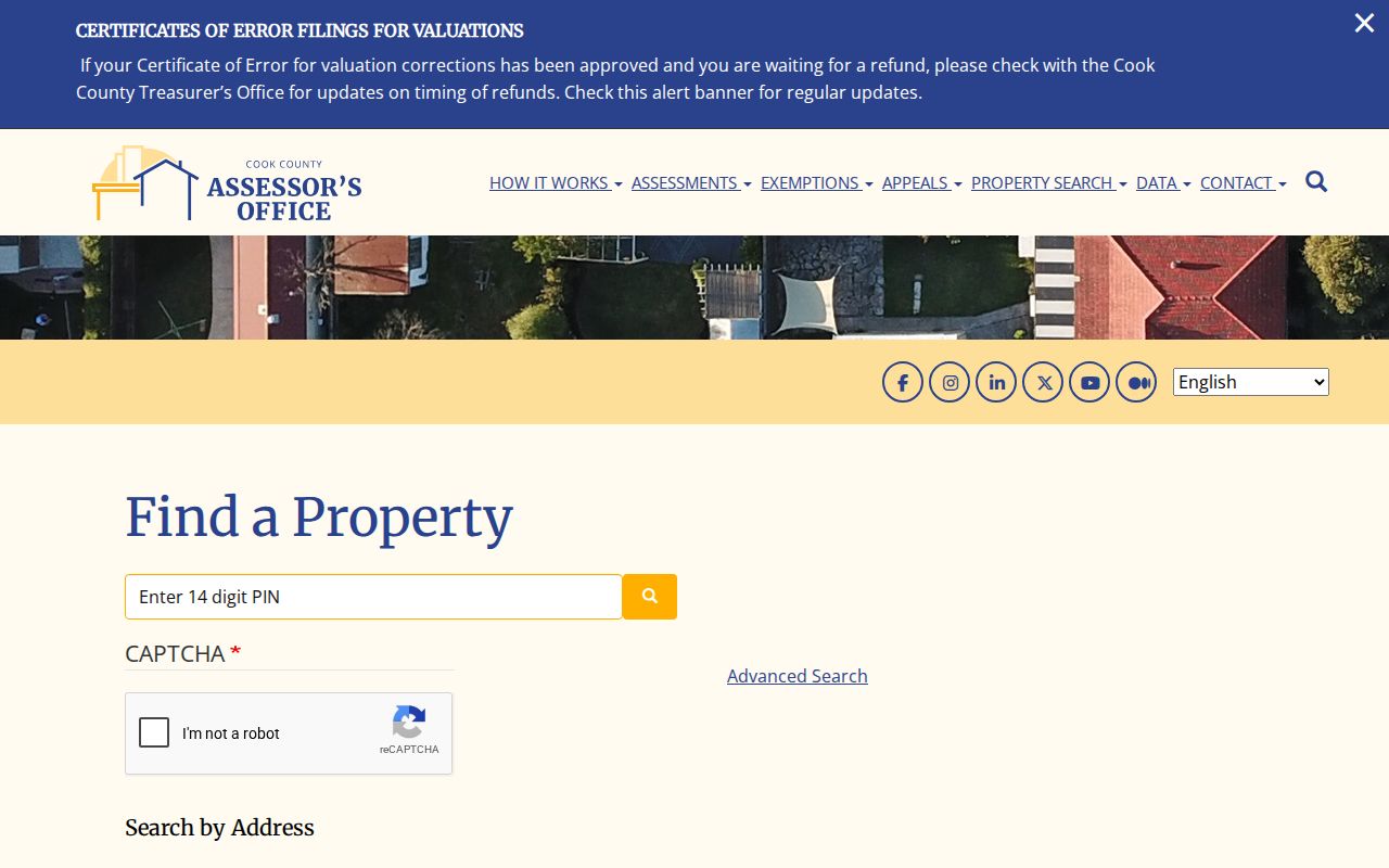
The form's separate inputs explain why a close spelling or an omitted unit can affect a street-level match.
CookViewer Parcels Along a Street
CookViewer searches 10-digit, 14-digit, or dashed PINs, addresses, and street intersections. Results appear in a Property Results panel; map clicks also open parcel details. Intersections help when a house number is uncertain.
Zoom to a block and use Select Tool to click parcels or draw a rectangle or polygon. Export results to CSV or Excel. Radius comparison offers eighth-, quarter-, half-mile, and one-mile ranges, with filters for building or land size, construction type, and age. Layers include historical parcels, zoning, districts, and imagery. Cook GIS covers more than 1.8 million parcels and 12,000+ centerline miles.
Parcel details may show PIN, address, township, municipality, zoning, class, area, assessed values and history, imagery, and links to tax and Clerk property records. Export helps list block parcels, but the map does not show occupants. The portal notes mapping-service disruptions; keep the address and PIN if a layer fails.
Open the CookViewer map and search panel to inspect the current controls and available layers.
Illinois 1909 Address Conversion
Chicago changed north- and west-side addresses in 1909. The Lakeside Directory printed an old/new conversion list, and a permit card may show the earlier number. Search both numbers and compare the parcel, block, and nearby corners if a current address fails to match an older record.
This Chicago example is not a statewide renumbering rule. Illinois has no single street-change table. Elsewhere, check municipal clerk or planning records, plats, county GIS address points, and local 9-1-1 data for renames or annexations. Historical street-address indexes belong to the Illinois city directory collections, which vary by year.
Illinois required grantor/grantee indexes from 1847. IRAD holds transferred county records, but holdings vary. When a web search ends, ask the recorder which books cover the parcel, then check the IRAD guide.
Chicago Permits by Address
Chicago's public permit-status search generally shows applications begun in the prior 36 months. Address search is limited; application-number search is fuller. Results can show permit type, review program, start and issue dates, work description, holds, and zoning status. See the City permit-system instructions for its fields.
Application numbers are usually nine digits starting with 1; some B2 numbers use ten characters, while older assisted-developer numbers start with D and a hyphen. Save the result number and date for a records request.
An online status is not a full building file. Older applications or permits may be absent, and a permit does not prove work occurred. An inspection describes conditions at that time. Request older or fuller files from the Chicago Department of Buildings or its FOIA officer; other Illinois cities set their own search and retention rules.
Illinois Street Directory Records
Each street record answers a different question: assessors and GIS describe parcels, recorders index legal interests, permits describe work, and reverse directories reflect a past year. Voter access has statutory limits; no statewide portal joins every Illinois record.
| Address record | Illinois keeper | Street-level clue | Route and limit |
|---|---|---|---|
| Assessment card and tax roll | Township assessor or county Supervisor of Assessments; treasurer | Owner, PIN, situs, tax address, class, value, exemption | Portal, phone, or office; mailing address does not prove occupancy. |
| GIS parcel map | County GIS | Parcel outline, nearby lots, zoning or district layers | Public viewer; selection and export vary by county. |
| Deeds, liens, plats | Recorder or Clerk Recordings | Parties, type, date, PIN/legal description, book/page | Index, image/copy route, counter, tract books, or microfilm. |
| Voter registration records | State Board of Elections and local authority | Registered address and jurisdiction, subject to law | Cards have inspection rules; electronic data is restricted. |
| Permits and code cases | City building or inspection department | Applicant, work, inspection, date, or status | Online where offered; older files by request. |
| Reverse directory | Local library or archive | Past address-to-name or phone listing by year | Print, microfilm, or database; not a current roll. |
| USPS address lookup | Postal Service | Standard address and recognized postal city | Confirms format, not a person or owner. |
Join the records by PIN or legal description, not just by name. Keep situs and tax-mailing addresses separate; the latter may belong to an owner, agent, trust, or recipient elsewhere. A permit may name an agent rather than an occupant, and a historic directory covers only its publication year.
For older deeds absent online, ask the recorder for the book, page, tract, or microfilm. In some smaller counties, the county clerk also serves as recorder; verify the local office.
Illinois Deed Chain by PIN
Start with the parcel number or legal description and search both grantor and grantee indexes. A grantor transfers an interest; a grantee receives it. A person may appear as buyer, seller, lender, trustee, lien claimant, or releasee. Check the deed image or certified copy for legal wording and parcel description.
Capture parties, instrument type, recording date, document number, book/page, legal description, and any consideration, remarks, or prior reference. Search the last grantor backward as a grantee, checking the legal description at each step. A name alone can match another parcel or trust.
Cook's online computer index begins in 1985; older land records may need tract books and an in-person search. The Clerk Recordings portal is the official entry point. Other counties set their own online cutoffs and copy routes. If a web index ends, ask the recorder about volumes or microfilm, then check whether IRAD holds that county's records.
Illinois requires recorder entry books and grantor/grantee indexes, so an online gap can mean a paper-book search rather than a missing record.
Illinois Voter Record Limits
Public voter cards do not mean the statewide list is downloadable. Under 10 ILCS 5/4-8, cards may be inspected with special rules around the 27 days before an election. The electronic list is not a general public download; it may be viewed on screen at the Springfield SBE office during normal hours outside that period, but not printed, copied, transmitted, or altered through that route.
Records may include name, residence, precinct, ward, township, county, and legislative or congressional districts. The online lookup is for a voter checking their own status, not street-by-street searching. Data products have geographic and use limits, and protected ACP records must be omitted from public lists.
For lawful inspection, ask the local election authority. Do not build an unrestricted list from search results. A missing name may reflect list maintenance, a move, a protected record, or a different jurisdiction; it does not prove the person never lived there.
The State Board's computerized voter-data page describes the file products and statutory limits. Its separate registration lookup entry point serves the individual voter check.
Illinois ZIP and Street Names
A postal city, municipality, county, and ZIP polygon can differ. USPS's recognized city may not be the legal municipality, and one Illinois ZIP can cross county lines or include unincorporated areas. Verify delivery with USPS, then identify the county assessor and city permit office separately.
The state ZIP layer is a polygon reference, not a delivery list. Keep ZIP as one address field and use the PIN for parcel records. The Illinois ZIP code directory explains regional bands and postal limits.
What Illinois Street Records Cannot Show
Property records show an assessment or recorded interest, not everyone who lives there. The owner's mailing address may be elsewhere. The federal Driver's Privacy Protection Act restricts license data; utility lists, delivery records, protected voter data, and private rosters are not household directories. A permit applicant may not be an occupant.
Use records for lawful personal research and respect redactions and confidentiality programs. Illinois stalking law, 720 ILCS 5/12-7.3, covers conduct that causes fear or emotional distress; a public record does not permit monitoring, threats, or unwanted contact.
- Parcel
- A mapped piece of land identified in the local property system, often by a PIN.
- Situs address
- The physical address tied to the parcel, separate from an owner's tax mailing address.
- Legal description
- The land wording in a deed, such as lot and block or a township, section, and range.
- Plat
- A recorded map that lays out lots, blocks, streets, or easements for a subdivision.
- Criss-cross directory
- A historical directory organized by street address or phone number, where the collection includes one.
Lawful use. Use address records for personal, lawful research and do not use them to stalk, harass, threaten, or intimidate anyone. Protected addresses and private household details should stay private.